

XXXLutz Walking Tour


Interactive elevation profile
Create PDF
Tour-Details
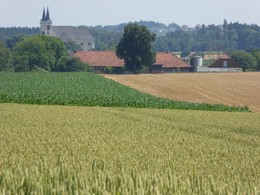
Starting place: 4642 Sattledt
Destination: 4642 Sattledt
duration: 1h 46m
length: 7,2 km
Altitude difference (uphill): 37m
Altitude difference (downhill): 11m
Lowest point: 386m
Highest point: 410m
difficulty: easy
condition: easy
panoramic view: Individual Views
Paths covering:
Asphalt, Gravel, Hiking trail
powered by TOURDATA
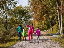
Short or long? The XXXLutz walking tour is perfect for a Sunday walk or a longer hiking trail.
The short route is 3.5 kilometers long and the longer one 6.5 kilometers. The route is also perfect for cyclists and walkers.
The short route is 3.5 kilometers long and the longer one 6.5 kilometers. The route is also perfect for cyclists and walkers.
")


")
")

Most economical season
- Spring
- Summer
- Autumn
Please get in touch for more information.
Stadtplatz 44
4642 Sattledt
Phone +43 7242 67722 - 22
E-Mail info@wels.at
Web www.wels.at
http://www.wels.at
Interactive elevation profile
Create PDF
Tour-Details
Starting place: 4642 Sattledt
Destination: 4642 Sattledt
duration: 1h 46m
length: 7,2 km
Altitude difference (uphill): 37m
Altitude difference (downhill): 11m
Lowest point: 386m
Highest point: 410m
difficulty: easy
condition: easy
panoramic view: Individual Views
Paths covering:
Asphalt, Gravel, Hiking trail
powered by TOURDATA