

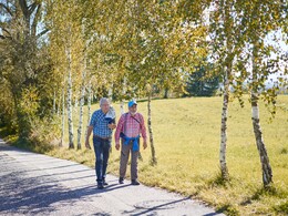
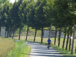
Strassers Walking Trail


- Flatly
Interactive elevation profile
Create PDF
Tour-Details
Starting place: 4642 Sattledt
Destination: 4642 Sattledt
duration: 1h 29m
length: 6,1 km
Altitude difference (uphill): 19m
Altitude difference (downhill): 19m
Lowest point: 390m
Highest point: 412m
difficulty: easy
condition: easy
panoramic view: Some Views
Paths covering:
Asphalt, Hiking trail
powered by TOURDATA
The Strassers Walking Trail is a beautiful hiking route The route is asphalted and easy to tackle with a stroller. The walking time of the 5.5 km long route is about 1 1/2 hours. The route is also perfect for a short bike ride or a walking tour. The Strassers Walking Trail is also perfect as a running route.
")
")
")


Most economical season
- Spring
- Summer
- Autumn
- Early winter
Please get in touch for more information.
Stadtplatz 44
4600 Wels
Phone +43 7242 67722 - 22
E-Mail info@wels.at
Web www.wels.at
http://www.wels.at
Interactive elevation profile
Create PDF
Tour-Details
Starting place: 4642 Sattledt
Destination: 4642 Sattledt
duration: 1h 29m
length: 6,1 km
Altitude difference (uphill): 19m
Altitude difference (downhill): 19m
Lowest point: 390m
Highest point: 412m
difficulty: easy
condition: easy
panoramic view: Some Views
Paths covering:
Asphalt, Hiking trail
powered by TOURDATA