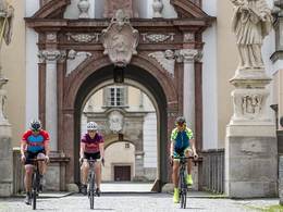
© Foto: Wels Marketing und Touristik: Burggarten Wels
Der Burggarten in Wels lädt zu einen Selfie ein
search
Search
Close

358 Cycle tour "Tassilorunde"

  • culturally interesting
  • Flatly

 Interactive elevation profile

Download GPS data
Create PDF

Tour-Details

Path number: 358
Starting place: 4540 Bad Hall
Destination: 4540 Bad Hall

duration: 3h 30m
length: 41,0 km
Altitude difference (uphill): 372m
Altitude difference (downhill): 378m

Lowest point: 317m
Highest point: 491m
difficulty: medium
condition: medium
panoramic view: Some Views

Paths covering:
Asphalt

powered by TOURDATA

Leisurely cycle tour with the most energy-saving route possible, focussing on culture.
The Bavarian Duke Tassilo founded the Benedictine monastery of Kremsmünster and endowed it with extensive land holdings - the monks were henceforth to spread Christianity and cultivate the region.
We want to follow in the duke's footsteps, cycling first via Rohr to Achleiten, steeply up to the castle and along the provincial cycle path into the Schacherwald forest. Quiet reigns at the ponds ... Perhaps images of the founding legend come to mind, as Tassilo's son Gunter once died in the deep woods while hunting boars. Heiligenkreuz then suddenly appears in the open countryside; the two church towers rise high into the sky, glowing mountains in the background - a sublime atmosphere!
Kirchberg offers an idyllic village square and a beautiful view of the mighty Kremsmünster Abbey - a little later we roll through the venerable oak gate into the monastery - Tassilo is still present here.
A very steep descent into the market square, then a relaxing ride along the Kremstalweg, before a longer uphill section tests our strength - the rest of the route is leisurely, allowing us to reflect on the enormous cultural developments since Tassilo's order to the monks in 777 ... all just an episode in geological history.

Path:
Eduard-Bach-Straße - Schulstraße - Rohr - Achleiten - Heiligenkreuz - Kirchberg - Kremsmünster - Feyregg - Eduard-Bach-Straße.


Our lovely blogger Angelika Mandler-Saul has written a wonderful report about our cycling region, which you can read here!
Travelling by public transport
Route planner for independent travellers
  • Suitable for groups
Most economical season
  • Spring
  • Summer
  • Autumn

Please get in touch for more information.


358 Cycle tour "Tassilorunde"
Tourismusverband Bad Hall
Kurpromenade 1
4540 Bad Hall

Phone +43 7258 7200
Fax machine +43 7258 7200
E-Mail info@badhall.at
Web www.badhall.at
http://www.badhall.at

We speak the following languages

German

 Interactive elevation profile

Download GPS data
Create PDF

Tour-Details

Path number: 358
Starting place: 4540 Bad Hall
Destination: 4540 Bad Hall

duration: 3h 30m
length: 41,0 km
Altitude difference (uphill): 372m
Altitude difference (downhill): 378m

Lowest point: 317m
Highest point: 491m
difficulty: medium
condition: medium
panoramic view: Some Views

Paths covering:
Asphalt

powered by TOURDATA