© Foto: Wels Marketing und Touristik: Burggarten Wels
Der Burggarten in Wels lädt zu einen Selfie ein
Accommodation Booking
Arrival
Departure:
<zurückVor>
Juni 2025
MoDiMiDoFrSaSo
      1
2345678
9101112131415
16171819202122
23242526272829
30      
<zurückVor>
Juni 2025
MoDiMiDoFrSaSo
      1
2345678
9101112131415
16171819202122
23242526272829
30      
search
Search
Close

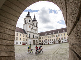
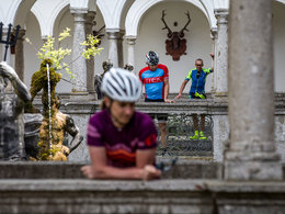
354 Cycle tour "Kultour"
  • culinary interesting
  • culturally interesting
  • Flatly

 Interactive elevation profile

Download GPS data
Create PDF

Tour-Details

Path number: 354
Starting place: 4540 Bad Hall
Destination: 4540 Bad Hall

duration: 2h 18m
length: 21,0 km
Altitude difference (uphill): 150m
Altitude difference (downhill): 150m

Lowest point: 318m
Highest point: 442m
difficulty: easy
condition: easy
panoramic view: Some Views

Paths covering:
Asphalt

powered by TOURDATA

Cycle route on quiet side roads without any significant gradients, also suitable for untrained cyclists.

In our region, culture is inextricably linked with Kremsmünster - Duke Tassilo founded the monastery in 777 and the settlement of the area began here.
Right at the start, the Klutur cycle tour takes us past the Tassilo spring in the Sulzbachtal valley, then continues swiftly via Feyregg to Dehenwang. In Brading, the road winds narrowly between farmsteads; down in the valley is the source of the Haller drinking water on Kremsmünster territory. After the next hilltop, the long descent finally comes - the ...
Travelling by public transport
Route planner for independent travellers
  • Suitable for groups
  • Suitable for schools
Most economical season
  • Spring
  • Summer
  • Autumn

Please get in touch for more information.


354 Cycle tour "Kultour"
Tourismusverband Bad Hall
Kurpromenade 1
4540 Bad Hall

Phone +43 7258 7200
Fax machine +43 7258 7200 - 20
E-Mail info@badhall.at
Web www.badhall.at
https://www.badhall.at

We speak the following languages

German

 Interactive elevation profile

Download GPS data
Create PDF

Tour-Details

Path number: 354
Starting place: 4540 Bad Hall
Destination: 4540 Bad Hall

duration: 2h 18m
length: 21,0 km
Altitude difference (uphill): 150m
Altitude difference (downhill): 150m

Lowest point: 318m
Highest point: 442m
difficulty: easy
condition: easy
panoramic view: Some Views

Paths covering:
Asphalt

powered by TOURDATA
Protected by