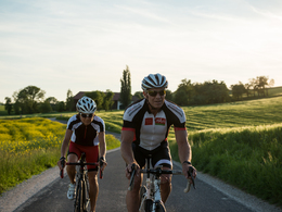
© Foto Oberösterreich Tourismus GmbH/Stefan Mayerhofer: Zuerst muss der Radhelm gut sitzen und dann kann die Rennradtour losgehen.
Drei sportliche Rennradfahrerinnen bereiten sich auf die Abfahrt vor. Eine Dame richtet sich gerade den Helm, alle tragen Helm und Sonnenbrille. Im Hintergrund Sträucher und Baumstämme.
search
Search
Close

Atterseetour - Around the most beautiful lake in Austria

  • Suitable for families
  • culinary interesting
  • culturally interesting

 Interactive elevation profile

Download GPS data
Create PDF

Tour-Details

Path number: RR011
Starting place: 4600 Wels
Destination: 4600 Wels

duration: 7h 52m
length: 149,8 km
Altitude difference (uphill): 1.353m
Altitude difference (downhill): 1.353m

Lowest point: 313m
Highest point: 855m
difficulty: very difficult
condition: very difficult
panoramic view: Dreamtour

Paths covering:
Asphalt

powered by TOURDATA

A beautiful day tour to the Salzkammergut and around the Attersee. This is a long but easy route with a longer ascent to the mountain stage of Hochlecken.

The tour to one of the most beautiful lakes in Austria is a long but not very demanding loop tour to the Attersee.

From Isola Bella on side roads towards Gmunden, via the Hochalmstraße to the Hochlecken mountain stage; on the descent towards Attersee, there is a magnificent view of the lake. Around the lake in a clockwise direction. Back to Wels in a figure-eight loop, finally over the Angerlehner Steg to ...
Travelling by public transport
Route planner for independent travellers
  • Suitable for groups
  • Suitable for single travelers
  • Suitable for families
  • Suitable for friends
  • Suitable for couples
Most economical season
  • Spring
  • Summer
  • Autumn

Please get in touch for more information.


Atterseetour - Around the most beautiful lake in Austria
Tourismusverband Region Wels
Stadtplatz 44
4600 Wels

Phone +43 7242 67722 - 22
E-Mail info@wels.at
Web www.wels.at/welsmarketing/rennradre…
http://www.wels.at/welsmarketing/rennradregion-wels.html

We speak the following languages

German

 Interactive elevation profile

Download GPS data
Create PDF

Tour-Details

Path number: RR011
Starting place: 4600 Wels
Destination: 4600 Wels

duration: 7h 52m
length: 149,8 km
Altitude difference (uphill): 1.353m
Altitude difference (downhill): 1.353m

Lowest point: 313m
Highest point: 855m
difficulty: very difficult
condition: very difficult
panoramic view: Dreamtour

Paths covering:
Asphalt

powered by TOURDATA
Protected by