

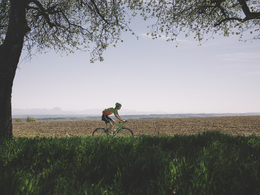
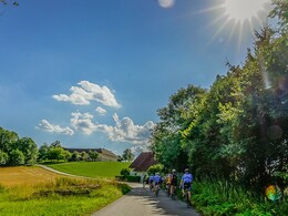
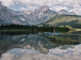
Almsee Tour


- Flatly
Interactive elevation profile
Create PDF
Tour-Details
Path number: RR0015
Starting place: 4600 Wels
Destination: 4600 Wels
duration: 5h 43m
length: 114,4 km
Altitude difference (uphill): 681m
Altitude difference (downhill): 681m
Lowest point: 313m
Highest point: 612m
difficulty: difficult
condition: difficult
panoramic view: Dreamtour
Paths covering:
Asphalt
powered by TOURDATA
A wonderful tour to the most idyllic lake in Austria. The Almsee is tranquilly located in the upper part of the Almtal valley.
This tour is not too difficult in topographical terms and takes you to the beautiful Almsee. The return leg can be made on the regional train as an alternative.
This tour is not too difficult in topographical terms and takes you to the beautiful Almsee. The return leg can be made on the regional train as an alternative.
")
")

Most economical season
- Spring
- Summer
- Autumn
Please get in touch for more information.
Stadtplatz 44
4600 Wels
Phone +43 7242 67722 - 22
E-Mail info@wels.at
Web www.wels.at/rennrad
http://www.wels.at/rennrad
Interactive elevation profile
Create PDF
Tour-Details
Path number: RR0015
Starting place: 4600 Wels
Destination: 4600 Wels
duration: 5h 43m
length: 114,4 km
Altitude difference (uphill): 681m
Altitude difference (downhill): 681m
Lowest point: 313m
Highest point: 612m
difficulty: difficult
condition: difficult
panoramic view: Dreamtour
Paths covering:
Asphalt
powered by TOURDATA